
I have plenty of things to write about in the last few months, but since I already have these pictures uploaded, I thought I'd give you a brief post about Andris and I's little mountain adventure back in July.
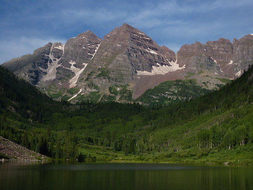
If you've ever seen a photo calendar of Colorado, you've probably seen the peak we climbed (pictured above). We climbed the peak on the left (South Maroon Bells peak, or sometimes just "Maroon Peak," that appears slightly lower (but is actually slightly higher).
Andris flew in to Denver (thanks!) Wednesday night, and because we're getting older and wiser, we decided to NOT try to directly climb something really high and stupid on Thursday. We waited until Friday for that. Last time we tried something similar, in 2005, Andris was also flying in from sea level (different coast then), and got himself a nice little case of altitude sickness. This time we slept at 7,000 ft the first night, then about 9,000 ft the second night before attempting to summit Maroon Bells peak (14,156 ft) near Aspen. The excellent route description we followed is available free at 14ers.org, and Andris even had it downloaded as a PDF on his phone. Hilarious. As a disclaimer for this route, 14ers.org says:
"This route holds some dangerous terrain and plenty of tedious route finding. Attempt the route only if you are in good shape, have ample time, and a favorable weather forecast." I agree on all counts.
Our drive-in forest service campground (Silver Bells, I think) was well located, pretty cheap, and had a great view. We were up and off to the trailhead before 5 am, trying to get the alpine start everyone loves so much. We hiked in the dark the first hour or so, before seeing the first alpenglow on the peaks near Crater Lake. The hike was uneventful as it stayed on the trail, but after about 1.5 hours, we had to leave the proper trail, as the route from there out was pretty much just UP. Almost 3,000 feet up, up, up the "massive East slope" to the ridge. There was not much of a trail, and all the rocks were loose and occasionally knocked loose. We put on our climbing helmets (SAFETY FIRST!) for protection from loose rock.
Colorado was in the middle of a July high-pressure heat wave. It was over 100F down in Denver, and still quite toasty up in the mountains. There was not a cloud in the sky the entire day, and we were above treeline and exposed to the high mountain sun from about 7 am to 6 pm...we got a little fried.
Once we attained the ridge, the hard part of the climb began. There is not any trail at all up here, just a suggested route picking your way around the rock outcroppings, talus slopes, and occasionaly precipitous drop-offs. There were about a half-dozen other climbers going our direction at about the same time, and given the narrow/sketchy nature of the climb, we kind of teamed up and took care of each other. A few times we saw some mountain goats flaunting their four legs and hooves, merrily scrambling up and over things we fretted cautiously over.
We successfully attained the summit (the view were amazing...up to 100 miles in some directions), and then, perhaps surprisingly, chose not to attempt the South Maroon Peak-North Maroon Peak traverse. I guess we are getting older and wiser. It would have meant another 14er to "bag", but I couldn't see how the view would be much different (only a few hundred meters away, and a little lower), traverse is considered sketchier than what we'd already done, and Andris was suffering a bit of mild altitude sickness. The mountain will be there next time. Another day.
On the way down, the technical scrambling was just as hard, probably more so with tired legs. Descending the "massive East slope" was awful. We could see where we were going for about 2 hours, but just had to pick our way slowly slowly slowly down, trying not to knock too many boulders down on each other off the steep unconsolidated slope. By the time we made it off the slope, we were thrilled to be on a semi-flat ground a real trail again. (See the picture of Andris hugging a tree at the bottom.) We still had another 2+ hours of hiking left, but it was uneventful trail walking. It was a long day: 15+ hours of hiking, 12 miles roundtrip, 4,800 ft of elevation gain. It was also a fabulous day in the wilderness. Thanks Andris, and thanks Colorado. See you next time!
My Flickr Slideshow is posted below. You can view it small embedded below, or (recommended) full-screen by clicking the button on the lower-right of the slideshow embedded image, the one that looks like four arrows pointing out to each corner. From this full-screen view, you can change the speed of the slideshow, and also toggle descriptions ("show info") on/off with the buttons on the upper right.
No comments:
Post a Comment