So earlier I mocked the unimpressive nature of Mother Earth's fury, as exhibited by Hurricane Tropical Storm Irene. I continue to hold that the actual storm was really quite boring as natural disasters go, at least around here. It rained for about 12 hours pretty continuously, but that's about it. We didn't get that much rain today (3.4 inches) and it never got super windy.
After that post however, I went for a walk around campus as the sky cleared. There was surprisingly little flooding anywhere near the academic and residential buildings, so I went to check out the lower athletic fields, and instead discovered a raging, frothy extension of the Deerfield River. But I forgot that the whole lovely valley that Deerfield is in is in fact a valley, and apparently it rained plenty upstream, up North in Vermont. According to the old timers, the last time the water got this high was the "Great New England Hurricane of 1938."
I stood on some steps by the gym for a few minutes, assisting a local man that was concerned about possible cries for help from the lower levels of the building (we never heard/found anything). As I stood on the steps, I had to go up a step after standing there only about 5 minutes. I think the water was rising an inch (vertically, not horizontally) a minute at that point. An inch a minute. The tennis courts went from normal to submerged over the nets in about 30 minutes. The rate of rise slowed down, but the river kept coming up all afternoon. I don't know Deerfield well enough (I've only been here 6 days!) to know exactly how everything looked before, but I would venture that there is at least 10 feet of water covering the football field (it was up to the crossbar of the uprights) and moving FAST. Water was flowing across main street and the 5/10 Highway (both north and south of town), so we are pretty cut off. We can still go up and over the ridge towards the Connecticut River, but flooding on that river might cover the river road over there soon too.
There were rumors earlier in the day that the Harriman Reservoir (upstream in Vermont - the biggest rez in Vermont) had burst. As far as I can tell, that rumor is false, but officials are concerned about the stability of several upstream dams. The highway blockages are over 1/2 a mile from the river - there is a LOT of water down here. Several families have had to evacuate their houses in town, and the historic Deerfield Inn has water 4+ feet up the ground floor (many of the evacuees are staying at the Inn!). We're hoping that the river is done but some reports didn't expect it to crest until Tuesday. The Deerfield River dumps into the (normally) much larger Connecticut River a few miles downstream from here, but the Connecticut River is flooding too, so that could perhaps push water back up the Deerfield from below.
It could be interesting for a few days.
Here are some photos and video shot this afternoon/evening (August 28, 2011).
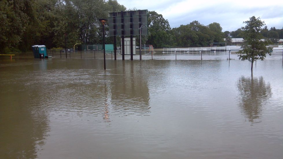
Looking at the lower athletic fields, with water up to the crossbars of the goalposts. A groundskeeper watching the flood remarked "I guess I won't have to line the field tomorrow."
Track flooded. This area had never in the memory of anyone in town (50+ years) flooded.
Water creeping up to the back of the shiny new Koch Technology center, where I'll be teaching. I hope they put up some sand bags and/or the water stops rising soon.
Measuring how fast the water has risen at the historic Deerfield Inn.
Deerfield Fire Department: lots of antiquated emergency equipment got some use today.
Main Street of Historic Deerfield around 5 pm. The red house on the left was faculty housing that was evacuated.
We tried to buy emergency supplies on Friday, but the grocery store was cleaned out of water, and our camping water filter is still in storage. We bought 50 16oz Solo cups and filled them with tap water before the storm. We've never lost water/power, but I'm a little concerned about the quality of drinking water with the river now covering many cow farms and outhouses. Emergency water ration flip cup, anyone?
Highway 5/10 heading south out of town. It was similarly blocked about 1/2 north of town.
View of the flooded valley from "The Rock" on Pocumtuck Ridge. The Deerfield Academy campus is roughly in the middle of the photo.
Another view from the Rock. The flooded area in the far right (next to a large building, which is the Deerfield gymnasium) is where the athletic fields are that are shown in the video above.
UPDATE: I found the USGS stream gage info for the Deerfield. Note that the median flow this time of year is 300 cfs (cubic feet per second) and about 3 feet deep, which is a pretty mellow river. Within less than two hours after Irene, it shot up to 100,000 cfs, and was running almost 25 feet deep! The good news is that it appears to be heading back down now. Whew.


No comments:
Post a Comment